Showing posts with label Irrigation. Show all posts
Moisture Contents of Soil

Moisture Contents of Soil

Field Capacity:

  • It is the amount of water that remains in the soil after all the excess water at saturation has been drained out.
  • when sandy soils are allowed to drain for approximately 24 hours after saturation, field capacity is reached.

Saturation Capacity:

  • It is the soil water content where all soil pores are filled with water and water readily percolates or drains out from the root zone by gravitational force.
  • The metric suction at this condition is almost zero and it is equal to the free water surface.

Permanent Wilting Point:

  • Permanent wilting point is considered as the lower limit of available soil moisture.
  • At this stage, water is held tightly by the soil particles that the plant roots can no longer obtain enough water to satisfy the transpiration requirements; and remain wilted unless the moisture is replenished.

Readily available moisture: 

  • Readily available moisture is that portion of available moisture that can be most readily extracted by plants.
  • In general, readily available moisture is approx 75 % of the available moisture.

Available moisture:

  • The difference in water content of soil between field capacity and the permanent wilting point is called available moisture.

SC = Saturation capacity, FC = Field capacity, OMC = Optimum moisture content, PWP = Permanent welting point and UWP = Ultimate welting

Irrigation and Its Methods in Civil Engineering Study

Irrigation and Its Methods in Civil Engineering Study

Irrigation and Its Methods for Engineering Purpose

Irrigation


CHAPTER HIGHLIGHTS

☞ Introduction
☞ Types of irrigation
☞ Methods of irrigation
☞ Water requirements of crops
☞ Irrigation efficiencies
☞ Irrigation requirements of crops
☞ Crop seasons
☞ Water logging and drainage


GENERAL UNDERSTANDING

The following are the main concerns on irrigation:-

1 How to apply

  • i.e. what should be the method of irrigation: Border Flooding method, furrow irrigation method,sprinkler irrigation method, drip irrigation method etc.

2.How much apply

  • i.e. how much moisture the soil can hold in its pores or Moisture holding capacity of Soil.

3.When to apply

  • i.e. when has the soil moisture level depleted to 50 to 60% of moisture holding capacity and when is the time to irrigate. In other words, what should be the frequency of irrigation.


DEFINITION OF IRRIGATION

Irrigation may be defined as the science of artificial application of water to the land, in accordance with the crop requirements throughout the crop period for full-fledged nourishment of the crops.


CROP YIELD AND PRODUCTION IN IRRIGATION

The crop yield from irrigation is expressed as quintal/ha or tonnes/ha. The productivity of the crop is expressed as crop yield per mm of water applied.

Increase of yield or Productivity can be achieved by following methods in IRRIGATION

  • Land shaping or land leveling
  • Suitable crop rotation and crop planing
  • Using high yielding varieties of seeds
  • Using chemicals and Fertilizers
  • Suitable methods of Irrigation adopted.
  • Lining of canal and other bodies.
  • Drainage of Irrigated land by surface and subsurface drainage.

ADVANTAGES AND DISADVANTAGES OF IRRIGATION

Advantages of Irrigation

Direct advantages of IRRIGATION

  • Increase in food Production
  • Protection against drought
  • Revenue generation
  • Mixed Cropping

Indirect advantages of IRRIGATION

  • Power generation
  • Transportation
  • Ground water table
  • Employment

Disadvantage of Irrigation

  • Water logging due to excess irrigation
  • Ground water pollution due to seepage of nitrates resent in soil as fertilizer etc.

Overall Benefits of Irrigation

  • 1. Increase in food production
  • 2. Protection from famine
  • 3. Cultivation of cash crops
  • 4. Eliminating mixed cropping
  • 5. Addition to the wealth of the country
  • 6. Generation of hydroelectric power
  • 7. Domestic and industrial water supply
  • 8. Inland navigation
  • 9. Canal planting
  • 10. Improvement of ground water storage

Effects of Irrigation

  • 1. Breeding places of mosquitoes
  • 2. Water logging
  • 3. Damp climate

TYPES OF IRRIGATION PROJECTS


Irrigation projectsIrrigation Potential (CCA)Cost of Project
Major>10000 ha>5 crores
Medium2000 - 10000 ha>.5 to 5 crores
Smallless than 2000 ha>.25 to .5 crores

TYPES OF IRRIGATION


Types of Irrigation

Flow Irrigation

Lift Irrigation

Perennial IrriagationDirect IrrigationInundation IrrigationStorage IrrigationCombined Storage and Diversion scheme(well irrigation)
(The water required is supplied to the crop through out the year) (diversion scheme) (or) (River canal irrigation) (Water is directly diverted to canal without storing) (The irrigation is carried out by deep flooding) (storage scheme) (or) (Tank irrigation) (Water is stored in dam (or) reservoir) (Water is stored in dam (or) reservoir and then diverted to canal) (Subsoil water is lifted to the Surface and conveyed to agricultural fields.)


  • 1. Surface irrigation.
  • 2. Subsurface irrigation.

Surface irrigation

Surface irrigation can be further classified into 
a. Flow irrigation.- i.e. flow under the action of gravity
b. Lift irrigation.- i.e. water is lifted by pumps etc for supplying water.

Flow irrigation can be further sub-divide into
x. Perennial irrigation - water is supplied on whole base period or continuous required water supply.
y. Flood irrigation - uncontrolled irrigation or soil is kept submerged and thoroughly flooded with water.

Sub-surface irrigation

Sub-surface irrigation may be divided into two types.
a. Natural sub-irrigation - water leakage from channels etc.
b. Artificial sub-irrigation - by artificial mechanism.


METHODS OF IRRIGATION

  • Free flooding method
  • Border flooding method
  • Check flooding method
  • Basin flooding method
  • Furrow irrigation method
  • Sprinkler irrigation method
  • Drip irrigation method

Free flooding or Ordinary flooding

  • Also called wild flooding as the movement of water is not restricted.
  • Initial cost of land preparation is low but labour requirement are usually high.
  • Water application efficiency is also low
  • Suitable for close growing crops, pastures, etc. particularly where land is steep.
  • It may be used on rolling land or topography irregular where borders, checks, basins,furrows are not feasible.

Border flooding

  • Land is divided into no of strips, separated by low levees called borders.
  • Each strip is of 10 to 20 metres in width and 100 to 400 m in length.
  • Water flows slowly toward the lower end and it infiltrates into the soil as it advances.
  • When water reaches the lower end of the strip the supply is turned off.
  • Size of supply ditch depends upon the infiltration rate of the soil and width of border strip.
  • This method is most popular.

Check Flooding

  • Similar to ordinary flooding except water is controlled by surrounding checked area with levees.
  • Close growing crops such as jowar or paddy are preferred.
  • Deep homogeneous loam or clay soils with medium infiltration rates are preferred
  • Suitable for both more permeable and less permeable soils 
  • less time required for highly permeable soil and vice-versa.

Basin flooding

  • Special type of check flooding and adopted specially for orchard trees.
  • One or more trees are generally placed in the basin and surface is flooded.
  • Shape of basin can be square, rectangular, circular or it may be irregular.
  • Flatter the land surface, easier it is to construct the basin
  • Coarse sands are not suitable for basin irrigation Because of high percolation losses.
  • Size and shape of basins are mainly determined by the land slope. the soil type, the available stream, the required depth of irrigation water to the applied.

Furrow Irrigation or Furrow method

  • Water is applied to the land to be irrigated by series of furrows
  • Furrows are small, parallel channels, made to carry water for irrigating the crops.
  • Infiltrated water spreads laterally between furrows.
  • The crops are usually grown on the ridges between the furrow.
  • One half to one fifth area of land is wetted.
  • Suitable for wide range of soil types, crops and land slopes.
  • Preferred on uniformly flat or gentle slopes which should not exceed .5%.
  • furrows can also be similar to long narrow basin.
  • labor requirement and land preparation is reduced as compare to flooding.

Sprinkler irrigation method

  • In the form of spray over crop through pipe system.
  • Known as overhead irrigation.
  • Used for all types of crops except rice and jute.
  • Used for all types of soils except very heavy soils with low infiltration rates.
  • Beset suited for very light soils as deep percolation losses are avoided.
  • This suit undulating topography and hence land leveling is not necessary.
  • This methods is used mainly by cultivation of tea coffee and vegetables in out country.
Notes :- 
  • for rice and jute standing water is required
  • light soils are sandy and silty with very little clay. generally easy to work, warm up quickly, dry out rapidly.

Drip irrigation method

  • Latest method.
  • Popular in areas with acute scarcity of irrigation water and salt problems.
  • Water and fertilizer is slowly and directly applied to the root zone of the plants in order to reduce losses due to evaporation and percolation.
  • Also known as Trickle irrigation
  • Help of specially designed emitter and drippers.
  • Centrifugal pump is best suited for this method.
  • Best suited for row crops such as tomatoes, grapes,corn,citrus,melons,fruits,cauliflower,cabbage etc.

Water Requirements of Crops

  • The water holding capacity of soil is the main characteristics which has to be taken into account for ideal irrigation. Thus the following topics deal with the water holding characteristics of soil and the parameters which help to measure it.

Classes of Soil Water

1. Saturation capacity:

  • The amount of water required to fill the pore spaces between soil particles by replacing all air held in pore spaces. It is also called maximum moisture holding capacity or total capacity.

2. Field capacity:

  • It is the moisture content of soil after free drainage has removed most of gravity water. It is the upper limit of water content available to plant roots.

3. Permanent wilting point:

  • Plants can no longer extract sufficient water from the soil for its growth.This is also known as wilting coefficient. If the plant does not get sufficient water to meet its needs,it will wilt permanently. For most of the soils wilting coefficient is about 150% of hygroscopic water.

4. Temporary wilting:

  • This will take place on a hot windy day but plant will recover in cooler day.

5. Ultimate wilting:

  • At ultimate wilting point the plant will not regain its turgidity even after addition of sufficient water to the soil and the plant will die. It is similar to hygroscopic coefficient.
  • Hygroscopic coefficient = 2/3(permanent wilting point)

6. Available moisture:

  • Moisture content of soil between field capacity and permanent wilting point.

7. Readily available moisture:

  • 75% of available moisture is known as readily available moisture. Readily available moisture depth, d w = S × d (Field capacity – Optimum moisture) = Sd (FC – OM)

8. Moisture equivalent

  • = Field capacity = (1.8 to 2) × (Permanent wilting point) = 2.7 (Hygroscopic coefficient)

9. Available moisture depth

  • = (d w ) = Sg × d × [F C – w C]
  • Where
    S g = Apparent specific gravity of soil
    F c = Field capacity
    w c = Wilting coefficient.

10. Frequency of irrigation

  • f= dw/Cu
  • Where dw = Readily available moisture depth
  • cu = Evapo-transpiration loss

11. Base period:

  • Total time between first watering done for preparation of land for sowing of crop and last watering done before its harvesting is called base period.

12. Crop period:

  • Total time elapsed between sowing of crop and its harvesting is called crop period.

13. Duty (D):

  • It is the area of land in hectares which can be irrigated for growing any crop if one cumec of water is supplied continuously to the land for entire base period of crop.

14. Delta (∆):

  • Total depth of water over the irrigated land required by a crop grown on it during the entire base period of the crop.
  • Crop Average = Delta (cm)
  • Rice = 120
  • Wheat = 37.5
  • Cotton = 45
  • Tobacco = 60
  • Sugarcane = 90
`Duty  = 8.64 × Base period / Delta`
B = Base period in days
∆ = delta in metres.

15. Consumptive use or evapotranspiration:

  • It is thetotal loss of water due to plants transpiration and evaporation from the land.
  • Lysimeter is used to measure Cu .One cumec day = 8.64 hectare metres, it is a volumetric unit.
  • It is total volume of water supplied@ 1 cumec in a day.


Irrigation Efficiencies

1. Water conveyance efficiency ( η c ):

  • It is the ratio of quantity of water delivered to the field to the quantity of water diverted into the canal system from reservoir.

2. Water application efficiency ( η a ):

  • It is the ratio of quantity of water stored in the root zone of plants to the quantity of water delivered to the fields.

3. Water use efficiency ( η u ):

  • It is the ratio of quantity of water used beneficially including the water required for leaching to the quantity of water delivered.

4. Water storage efficiency [ η s ]:

  • Ratio of quantity of water stored in the root zone during irrigation to the quantity of water needed to bring water content of the soil to field capacity.

Irrigation Requirements of Crops

1. Consumptive irrigation requirements (CIR):

It is the amount of water required to meet the evapotranspiration needs of a crop CIR = Cu − Re

Re = Effective rainfall

2. Net irrigation requirement (NIR):

Amount of irrigation water required to be delivered at the field to meet evapotranspiration and other needs such as leaching NIR = Cu – Re + Le

Where, L e = leaching

3. Field irrigation requirement

`(FIR) = NIR/ ηa`

4. Gross irrigation requirement

`(GIR) = FIR / ηc`


5. Paleo irrigation:

  • It is the watering done prior to sowing of crop.

6. Kor watering:

  • The first watering after the plants have grown few cm high is known as kor watering

7. Outlet factor:

  • Duty of water at canal outlet is known as outlet factor.

8. Gross command area (GCA):

  • Total area which can be irrigated by canal system if unlimited quantity of water is available is known as gross command area.

9. Culturable command area (CCA):

  • The portion of the GCA which is culturable or cultivable.
  • CCA = GCA – Uncultivable area

10. Culturable cultivated area:

  • That portion of CCA which is actually cultivated during a crop season.

11. Capacity factor:

  • Ratio of mean discharge of canal for a certain duration to its maximum discharge capacity.

12. Time factor:

  • Ratio of number of days the canal has actually run during a watering period to the total number of days of the watering period.

Crop Seasons

1. Kharif crops:

  • These are the crops which are sown in the month of April and harvested in the month of September. Examples: Rice, maize.

2. Rabi crops:

  • These are the crops which are sown in October and harvested in March. (Also called winter crops) Examples: Wheat, tobacco.

3. Perennial crops:

  • These are the crops for which the water is supplied throughout the year. Example: Sugarcane

4. Hot weather crops:

  • These are the crops which are grown between Kharif and Rabi season, i.e., from February to June.

5. Summer crops:

  • The hot weather crops and Kharif crops are combinedly called as summer crops.

6. Dry crops:

  • Crops grown without irrigation and depend only on rainfall for survival.

7. Wet crops:

  • The crops which require irrigation are known as wet crops.


Water Logging and Drainage


Water Logging

  • It is the condition in which there is excessive moisture in the soil making the land less productive.
  • The depth of water table at which it tends to make the land, water logged, depends on the
  • 1. height of capillary fringe and
  • 2. type of crop.


Causes of Water Logging

  • 1. Excessive rainfall in the area
  • 2. Flat ground profile
  • 3. Improper drainage of surface run-off
  • 4. Excessive irrigation


Effects of Water Logging

  • 1. Causes anaerobic conditions near roots of plants.
  • 2. Causes salinity of soil.
  • 3. Causes growth of wild aquatic plants.
  • 4. Lowers the soil temperature which effects the activities of bacteria.
  • 5. It makes cultivation difficult as the water logged areas cannot be easily cultivated.


Water Logging Control

  • 1. By providing efficient under drainage
  • 2. By preventing seepage from reservoirs
  • 3. By introducing crop rotation
  • 4. By improving natural drainage of area
  • 5. By introducing lift irrigation


Drainage

  • It is the means of preventing land from getting water logged as well as to receive the land already water logged.
Irrigation - Civil Engineering

Irrigation - Civil Engineering

Irrigation

Civil Engineering


Types of Irrigation

Flow Irrigation

Lift Irrigation

Perennial Irriagation Direct Irrigation Inundation Irrigation Storage Irrigation Combined Storage and Diversion scheme (well irrigation)
(The water required is supplied to the crop through out the year)  (diversion scheme) (or) (River canal irrigation) (Water is directly diverted to canal without storing)  (The irrigation is carried out by deep flooding)  (storage scheme) (or) (Tank irrigation) (Water is stored in dam (or) reservoir)  (Water is stored in dam (or) reservoir and then diverted to canal)  (Subsoil water is lifted to the Surface and conveyed to agricultural fields.)


All study of Irrigation in Civil Engineering in Exam point of view 

click here or go to following site


Garret's diagram

It gives the graphical method of designing the channel dimensions based on Kennedy's Theory.


The diagram has discharge plotted on the abscissa and the ordinates on the left indicate the slope and on the right water depth in the channel and critical velocity (Vo).

Kennedy's theory

R.G. Kennedy studied a number of sites at Upper Baro Doab System (now in Punjab) for carrying out investigations about the velocity and depth of channels.
According to him, Critical velocity (Vo) is the mean velocity that will just keep the channel free from sitting and scouring and related it to depth.

Modified critical Velocity, 
Vo=0.55md0.64


Where, d = depth of the channel (m), m = Critical velocity ratio (V / Vo) (For sand m = 1.1 to 1.2, for finer sand other than standard m = 0.9 to 0.8)

Further, the Critical Velocity ratio (CVR) is the ratio of actual velocity (Va) to critical velocity (Vc) in the channel.

Now If,

CVR > 1 Va > Vc Scouring will occur.

CVR < 1 Va < Vc Silting will occur

CVR = 1 Va = Vc There will be no silting and scouring
For calculating velocity, He used Kutter's formula and Manning's formula.

Kutter formula

  • `V=\left[\frac{\frac1N+\left(23+\frac{0.00155}S\right)}{1+\left(23+\frac{0.00155}S\right)\frac N{\sqrt R}}\right]`
where, R = hydraulic radius
S = slope or gradient

Manning Formula


  • `V=\frac1NR^\frac2{3}\sqrt S`

Meandering

  • A meander is formed when moving water in a stream erodes the outer banks and widens its valley and the inner part of the river has less energy and deposits what it is carrying.
  • A wave phenomena.
  • A Meandering river is a river that contains many bends throughout its length.

Causes of Meandering

  • Extra turbulence generated by the excess of river sediment during floods.
  • Size and grade of sediments that make up the river bed.
  • Valley slope.
  • Bed slope and side slope of the channel.
  • Main cause is Extra turbulence generated by the excess of river sediment during floods.


Meander Parameters:


Meander Length (ML) - The tangential distance between the crests or trough of a mender in plan view.
Meander belt width (MB) - Distance between top and bottom portion of successive crests and trough of a member in plan view.
Meander ratio - Ratio of meander belt width to meander length.
Tortuosity or sinuosity -  Ratio of archual length (length along the channel) to the direct axial length.


Head Sluices (or Canal Head Regulator):

  • A head sluices or canal head regulator (CHR) is provided at the head of the off-taking canal, and serves the following functions:
  • It controls the entry of the silt in the canal.
  • It regulates the supply of water entering the canal.
  • It prevents the river floods from entering the canal.

Silt Ejectors (or Silt extractors): 

  • These are the devices that extract the silt from the canal water after the silted water has traveled a certain distance in the off-take canal. 
  • These works are, therefore, constructed on the bed of the canal, and a little distance downstream from the head regulator.

Under-Sluices (or Scouring Sluices): 

  • The under sluices are the openings that are located on the same side as the off-taking canal and are fully controlled by gates, provided in the weir wall with their crest at a low level. 
  • Their main functions are:
  • It helps in controlling the silt entry into the canal.
  • It scours the silt deposited on the river bed above the approach channel.
  • It passes the low floods without dropping the shutter of the main weir.
  • It preserves a clear and defined river channel approaching the regulator.

Divide Walls: 

  • Divide wall is a masonry or concrete wall constructed at the right angle to the axis of the weir. 
  • Its main objective is to form a still and comparatively less turbulent water pocket in front of the canal head regulator so that the suspended silt can be settled down 
  • which then later be cleaned through the scouring sluices from time to time.


As per Lacey’s formula, the relation between discharge, Q, and the wetted perimeter is given as:

P=4.75√Q

For a rectangular channel, wetted perimeter P is given as:
P = B + 2 × y
Where y is the depth of flow.
If the channel is very wide the P ≈ B (as y ≪ B)

According to Lacey's theory, the following formulae has been given below:

Velocity of flow, V
Hydraulic mean depth, R
Area of the channel section, A
Wetted perimeter, P
Bed Slope, S


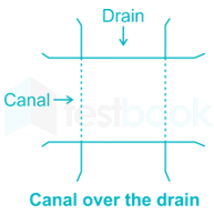
The drainage water intercepting the canal can be classified in the following ways:


i) By passing the canal over the drainage


a) Aqueduct


b) Syphon aqueduct


ii) By passing the canal below the drainage


a) Superpassage


b) Syphon


iii) By the drain through canal ⇒ 

  • a) level crossing
  • b) inlets and outlets


Tile drains or under drains


They are located at suitable depths below the ground surface above the impervious soil (clay) which prevent natural percolation of water and usually covered with coarse sand or bajri.
They are preferably placed in a soil of medium or high permeability.
The Tile drains permit deep root development by lowering the water table.
Tile drains have their outlets in natural as well as artificial channels.
Gravitational water at the head of the tile drain is under pressure due to head of water above it.

Drainage coefficient


Drainage coefficient is the rate at which water is removed by a drain.
It is expressed as depth of water in cms or meters to be removed in 24 hours from the drainage area.
It depends on rainfall, type of soil, type of crop, degree of surface drainage etc.
Its recommended value is 1 % of the average annual rainfall to be removed per day.


As per Lacey’s Theory, Normal scour depth is given by :

Case 1: If river width equal to the regime width of 4.75 √Q ; Q is the Discharge

R=C(Qf)13


`V=\left(\frac{Qf^2}{140}\right)^\frac16`

Where, C is constant, generally taken 0.473.

Q = Design flood discharge and

f = Silt factor and it is given as   

f = 1.76 √d; d is particle size in mm

Case 2: For all other values of actual width of river the normal scour depth is given as:

R=c(q2f)13

Where,

C = 1.35 and q is the discharge per unit width.

Further,

Maximum scour depth Smax = K × R

Where, K = 2 (Constant for piers)


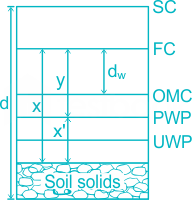
It is a phenomenon in which the productivity of land gets affected due to the high water table leading to flooding of the root zone of the plants and making the root zones of the plants ill-aerated.
  • Over and intensive irrigation
  • Seepage of water from the adjoining lands
  • Impervious obstruction
  • Inadequate surface drainage
  • Inadequate natural drainage
  • Heavy rains
  • Submergence due to floods High water table


Lift irrigation:

  • Irrigation with which water is supplied to the system by water-lifting devices is called pumping/mechanical/lift irrigation (by means of mechanical water-lifting devices).
  • It has high operating costs. 
  • It has fewer problems with waterlogging.

Extensive irrigation:

  • These systems are more costly to build and to maintain.
  • Irrigation service provided to end-users is often limited to only two to three irrigations per season.
  • These systems often have fewer problems with waterlogging and salinity and provide incentives for the conjunctive use of ground and surface water.

Intensive irrigation

  • This system uses a large amount of water, labour, and resources for a small area in order to increase production and yield.
  • More prone to waterlogging as no limit to the amount of irrigation water.